
Southwest Florida prepares for impacts of Hurricane Helene
Storm surge, tropical-storm-force winds expected
Trending
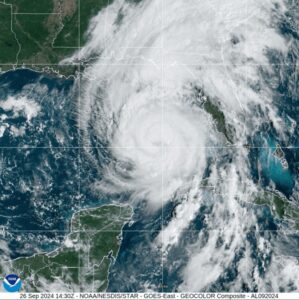
As Hurricane Helene continues to barrel its way through the Gulf of Mexico heading towards the Big Bend region of Florida, local officials have spread the word on what Southwest Florida residents can expect.
Tropical-storm-force winds will make its way through Lee County and beyond, with storm surge warnings in effect for Lee County. Some roads in Cape Coral were already closed as of Thursday morning due to flooding.
County officials said they are in close communication with state and federal partners, including the Florida Division of Emergency Management, the National Weather Service and the National Hurricane Center.
According to the 11 a.m. update on Thursday from the National Hurricane Center, “A significant increase in forward speed is expected during the next 24 hours. On the forecast track, Helene will make landfall in the Florida Big Bend region (Thursday) evening. After landfall, Helene is expected to turn northwestward and slow down over the Tennessee Valley on Friday and Saturday. “Maximum sustained winds have increased to near 105 mph with higher gusts. Additional strengthening is forecast, and Helene is expected to be a major hurricane when it reaches the Florida Big Bend coast (Thursday) evening. Weakening is expected after landfall, but Helene’s fast forward speed will allow strong, damaging winds, especially in gusts, to penetrate well inland across the southeastern United States, including over the higher terrain of the southern Appalachians.”
During a Thursday afternoon update, Lee County Director of Public Safety, Ben Abes, said “There may be blue skies intermittently, but we expend more bands of wind and rain (Thursday) afternoon.
“Helene for our community has more been an exercise in preparedness. It’s not coming directly at us, and we haven’t experienced any of the wobbles that we have seen with other storms. But it’s one of the reasons why we continue to encourage the community to be prepared each and every day for tropical weather, as well as all hazards that may impact the community.”
County officials and Emergency Management encouraged all residents to stay home, if possible, throughout Thursday, as Helene's bands of inclement weather will continue to bring heavy rain and strong, gusty winds. Even though the weather may clear for brief periods, residents were urged to stay indoors - especially this Thursday afternoon.
The Lee County Emergency Operations Center is fully staffed Thursday at a Level 2, with nearly all seats filled in Plans and Operations. Public Safety partners, including fire and law enforcement, is coordinating on response issues that arise due to the strong winds. The Department of Transportation (DOT), Natural Resources and Utilities are pre-positioning crews to respond to impacts once the storm passes.
Abes specially directed county residents to not visit barrier islands, such as Fort Myers Beach, Sanibel, Captiva, and Pine Island.
“After the storm passes, and depending on the severity of the wind, please use caution at all intersections in case traffic signals are not functioning,” Abes said. “And remember to treat any non-functioning signals as a four-way stop.”
Power outages were already reported as of Thursday afternoon, and LCEC stated via social media they will continue to work throughout the storm.
For those using a generator, it needs to be kept at least 20 feet away from doors and windows, and to point the exhaust away from the property.
Safe Havens that Lee County opened Wednesday remained open Thursday for those who do not feel secure in their housing situation and who perhaps do not have a friend's home or a family member's home to go to.
The two Safe Havens opened were at the North Fort Myers Recreation Center, and Estero Recreation Center. As of Thursday morning, the North Fort Myers site was housing 44 people, and Estero had 19. No evacuation orders were in place, and no hurricane shelters opened.
Officials recommended monitoring local media outlets, the National Weather Service-Tampa, and the National Hurricane Center.
Cape Coral officials encouraged residents to follow the City of Cape Coral Government on Facebook for current, up-to-date information at www.facebook.com/CityofCapeCoral and online at www.CapeCoral.gov for additional resources.
Residents who have not yet done so can sign up for AlertLee, which in addition to alerts about hurricane-related warnings and watches also provides tornado alerts. Visit www.leegov.com/hurricane/helene and scroll to the bottom of the landing page.
Fort Myers Beach
Fort Myers Beach Emergency Management continued to monitor the Tropical System in the Northwestern Caribbean as it moved toward Florida.
Officials said given the changes in the observations and forecast models, they expect to have a tropical depression and possibly a tropical storm formed Thursday evening.
“Residents should be reminded to stay vigilant and prepared,” town officials stated.
Town Hall had sand and bags available for residents, at 2731 Oak Street. Those that live in the areas prone to flooding, were cautioned that the Town’s stormwater system will not alleviate water breaching the seawalls from the back bay.
“Please be mindful that most of the Tier One project is still in progress, meaning drains may hold water for some time during significant rain events,” officials stated.
Sanibel
The City of Sanibel was closely monitoring the weather disturbance developing in northwestern Caribbean Sea. While models showed the storm tracking offshore, Sanibel will likely be impacted by winds from the south and southeast. Residents and businesses on Sanibel were strongly encouraged to check their Disaster Supply Kit and reconfirm a hurricane plan.
“”The key to weathering whatever Mother Nature sends our way is to have a plan and be prepared,” stated Mayor Richard Johnson. “Please pay close attention to weather updates from our local meteorologists and follow the guidance of public authorities if a threatening storm heads this way.”