
National Weather Service: Milton projected to hit Category 4 hurricane status; likely a Category 3 at landfall
Manatee County area in the sight zone but preparations from Big Bend to Naples urged
Trending
The forecast for Hurricane Milton grew more severe Sunday afternoon.
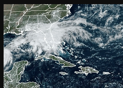
The National Weather Service is now predicting that Milton, currently 800 miles southwest of Tampa, will grow into a Category 3 hurricane on Monday in the Gulf of Mexico before strengthening into a Category 4 hurricane by Wednesday morning. Milton is currently projected to make a landfall south of Tampa Bay in the Manatee County area on Wednesday afternoon as a Category 3 hurricane.
The storm could bring a storm surge of 10 feet or more, National Weather Service meteorologist Rodney Wynn said.
In terms of definitive location, it’s still early yet, he said.
"We are telling everybody around the southwest coast to make preparations for a major hurricane from the Big Bend to Naples," Wynn said.
Wynn said a Category 3 hurricane could bring winds of 120 miles per hour with gusts of up to 150 miles per hour.
A Category 4 hurricane, like Hurricane Ian two years ago, would bring winds of 140 miles per hour and gusts of up to 170 miles per hour. Wynn said Milton "very well could be" as bad as Hurricane Ian in terms of storm surge.
Wynn said residents around Fort Myers Beach and Lee County can expect to see deteriorating conditions Tuesday evening as rainy conditions and flooding dangers grow worse and wind speeds pick up. Hurricane strength winds could begin to be felt as early as late Tuesday evening, Wynn said.
Town of Fort Myers Beach Manager Andy Hyatt issued a mandatory evacuation order for 3 p.m. on Monday. Sandbags will be available at the town hall from 7 a.m. to 3 p.m.
Lee County officials were poised to begin issuing evacuation orders on Monday. Gov. Ron DeSantis has issued a state of emergency for Lee County and 50 other counties in the state and warned of the threat of life-threatening storm surge.
“Mandatory evacuations are only as good as the people who listen to them,” Hyatt said.
Town residents should have their hurricane passes with them to return to the island. Town staff will also be stationed at Target after the hurricane to assist residents who forget to bring their hurricane passes.
Town of Fort Myers Beach Vice Mayor Jim Atterholt questioned town staff as to the pace of the pickup of debris from Hurricane Helene, which just started on Friday. Town of Fort Myers Beach Operations Manager Frankie Kropacek said the town is “piggybacking” on a Lee County contract for debris pickup. Kropacek said the debris pickup will resume Monday morning.
Some Fort Myers Beach residents have expressed concern that a lot of debris, particularly on the north end of town, has not been picked up yet with the latest hurricane looming. There is worry that the debris sitting in front of homes right now could become an additional hazard during Hurricane Milton if not picked up in time.
The National Hurricane Center has issued flood warnings for Lee County through Thursday.
"Everything along the coast will see impacts. You will definitely see storm surge," National Weather Service meteorologist Christianne Pearce said.
An estimated four to six inches of rain is expected through Thursday.
Lee County schools will close Monday through Thursday with some government offices also closing or closing early.
"We are well within the forecast cone and even if the storm shifts north or south we will have big impacts along our coastline," Lee County Public Safety Director Ben Abes said.
County offices will be open Monday at 8 a.m. and will close at noon. They will remain closed through Thursday. No other evacuation orders are in place as of late Sunday afternoon but expects to issue evacuation orders Monday but no later than Tuesday.
“Lee County anticipates announcing at noon Monday, Oct. 7, information about evacuation orders and shelter openings, as well as LeeTran service to those shelters,” county officials said in a release issued late Sunday afternoon.
Emergency centers are expected to begin opening on Monday.
“Residents who live in coastal areas or flood-prone inland areas do not need to wait for evacuation orders to mobilize. Go to friend or family members' homes or make arrangements to relocate inland.”
County updates may be viewed on local media, including The Breeze website, capecoralbreeze.com, as well as via the county’s Facebook Live at www.facebook.com/leecountyflbocc. Updates can also be viewed on LeeTV and on the Lee County Government YouTube channel.
The Town of Fort Myers Beach Council voted to postpone its Oct. 7 meeting to Oct. 15.
Atterholt suggests residents take photos of their homes inside and outside to use for insurance purposes.
“We all know how challenging some of our insurance partners have been,” Atterholt said.
Atterholt strongly advised all residents to leave the island.
"Everybody needs to be concerned," Atterholt said. "The volatility of this particular storm and the unpredictability of it really requires for the town to err on the side of caution."
Atterholt stayed on the island in a relatively safe area through Hurricane Ian and said he regretted it. "I urged everybody not to make that same mistake," he said.
"This could be devastating. We won't really know until it's almost too late to leave the island. We really want folks to err on the side of caution and be safe," Atterholt said.
"I think we saw from Helene that a hurricane far away can do a lot of damage and this is certainly coming a lot more direct than Helene was. It's definitely a cause for concern.
U.S. Senator Rick Scott, who visited Fort Myers Beach last week, said on Sunday that “Everyone along Florida's Gulf Coast needs to be ready. I know that barely one week out from Hurricane Helene's catastrophic landfall, it is unimaginable to have another major storm barreling toward our state - but you have to get prepared now because your life depends on it.”